Written By: Nilde Maggie Dannreuther and Stephanie Ellis of Gulf of Mexico Research Initiative
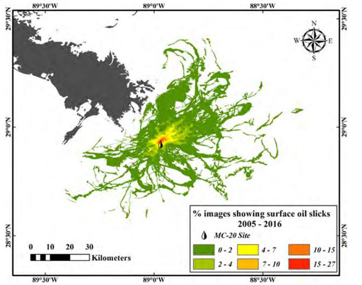
ST. PETERSBURG, FL – Researchers analyzed remote sensing imagery to assess oil slicks near the Taylor Energy platform, which was damaged by Hurricane Ivan in September 2004, and determined how environmental conditions affected the slicks’ distributions. Imagery showed no surface oil in most of 2004, but in 2005, 40% of cloud-free images showed slicks, and this number increased to 70% in 2006 – 2011 and >80% since 2012. Using all cloud-free images from 2005 to 2016, the team estimated an oil discharge rate of 48-1,700 barrels/day, which reached a cumulative area of approximately 1,900 km2 in the regions surrounding the Mississippi Delta. Their analyses suggest that the detected oil slick distribution can be largely explained by surface currents, winds, and density fronts associated with Mississippi River plumes.
The researchers published their findings in Marine Pollution Bulletin: Remote sensing assessment of oil spills near a damaged platform in the Gulf of Mexico.
After Hurricane Ivan damaged the Taylor Energy oil platform (Mississippi Canyon 20), there were seven months of near-daily aircraft overflights that reported oil slicks as large as approximately 1.6 km wide and 9 km long covering an average area of 20 km2. Despite mitigation efforts, the oil discharge has continued. Study author Chuanmin Hu explained, “The spill around the Taylor platform was originally thought to be negligible but it appears to be much larger, yet the impacts on the ecosystem are still unknown. Since initial surveys, there has been no systematic assessment to document the ongoing spill. Our paper represents the first study to present the spill’s history, with the spill’s footprint documented and spill volume estimated.”