By: Sarah Grasty, Education & Outreach/Research Project Manager
Florida, renowned for its vibrant maritime culture, is a hub in America's boating narrative.
The state’s profound connection to the ocean is underscored by the many maritime activities and industries that bolster its economy. Safe boating, whether for commercial shipping, fishing, or leisure, relies on one common element: nautical charts.
The Center for Ocean Mapping and Innovative Technologies (COMIT), at the University of South Florida College of Marine Science, is funded by the National Oceanic and Atmospheric Administration’s (NOAA) Office of Coast Survey to work on a range of projects related to seafloor mapping and coastal hazard response. One of these projects is focused on crowdsourcing seafloor depth data through a pilot program called Crowd the Bay.
Despite efforts to map and update charts in areas like Tampa Bay, some depth measurements are decades old. Across Florida, where coastal regions can change rapidly due to incessant current and tidal action, as well as more frequent and larger storms, timely seafloor depth data are paramount to safely navigating shallow waters.
Collecting and managing crowdsourced seafloor depth data – known as bathymetry – has been a global initiative for almost a decade through the International Hydrographic Organization. Crowd the Bay offers the first concentrated and sustained crowdsourced effort to measure seafloor depths along coastal Florida.
To contribute to crowdsourced bathymetry (CSB), vessels need only a National Marine Electronics Association (NMEA –pronounced nee-MA or nuh-me-UH) network, GPS antennas, a depth sounder, and a small data logger. The data logger records the other sensor feeds using the NMEA network while the boat operator goes about their regular business.
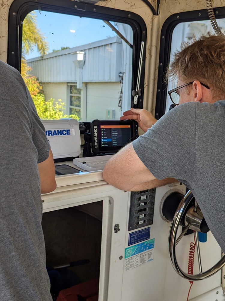
IMAGE ABOVE: Crowd the Bay team member, Matthew Hommeyer, installing a crowdsourced bathymetry data logger. The process typically only takes 30-45 minutes and can be done when a vessel is docked or trailered. Photo credit: Roxann Vistocci/Center for Ocean Mapping and Innovative Technologies.
“There are a staggering number of mariners out in Tampa Bay’s local waters. Many of these vessels have a sounder, regularly collecting depth measurements. These data have community and scientific significance, yet they disappear after they’re collected,” says Steve Murawski, director of COMIT and research professor at the College of Marine Science. “That’s the core of what we want to address with Crowd the Bay. Instead of letting those measurements disappear, we use very simple, easy-to-install loggers to record those data.”
Current participants in the program mainly include organizations who either attended one of Crowd the Bay’s stakeholder workshops in the last year or are frequent collaborators with COMIT personnel on other projects. The United States Geological Survey (USGS St. Petersburg Coastal & Marine Science Center), Chance Maritime, Ballyhoo Media, Pinellas County Environmental Management, Eckerd College, as well as some private citizens in the Tampa Bay Area are currently involved in the program. The list has grown organically through Crowd the Bay’s outreach efforts, and the program intends to keep adding participants as resources become available.
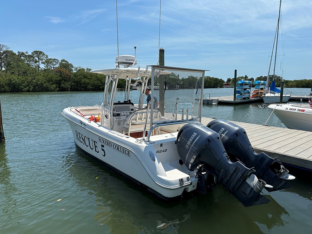
One of their most prolific participants thus far has been Eckerd College Search and Rescue (EC-SAR) Team. Crowd the Bay personnel installed data loggers, known as Mussel Kits from Orange Force Marine, on two of their four SAR vessels in early April. To date, Eckerd has collected more than 200,000 depth measurements along 50 miles in just over six weeks.
EC-SAR is a highly trained group of student volunteers and the only college maritime rescue team in the country. They’re also quite busy; EC-SAR responds to more than 500 maritime distress calls annually.
“We’re excited to contribute to a program like this and we’re hopeful the data will provide a significant benefit to our team,” says Ryan Dilkey, Eckerd’s associate director of waterfront operations. “With search and rescue, we often find ourselves going into some very shallow areas where there might not be much detail on our chart plotters. Having more information, especially when it’s been collected recently, would be extremely helpful to our operations.”
The team at Crowd the Bay provides each participant with the data they’ve collected in a preferred format. For some, a paper map is sufficient, while others request file types that can be imported into their own computer programs. COMIT has started processing the CSB data available in the Tampa Bay region, including some that’s being collected outside of the program, and will continue to update the map viewer and data on the Crowd the Bay website.
Crowd the Bay has been fortunate to build and form the program alongside different stakeholders, with the intent that this approach will better meet the needs of the community, while serving as blueprint for regional-scale CSB programs in other coastal areas.
CSB data aren’t yet regularly integrated into official charts in the United States, but they can help provide timely information for formal notices to mariners about safety hazards on the water, and these data also assists the Office of Coast Survey to prioritize new survey areas.
Though still in its pilot stage, Crowd the Bay is fully poised to become a sustained, larger program over the next year. More information about the program, including how to connect with the team if you’re interested in future participation, can be found on their website.
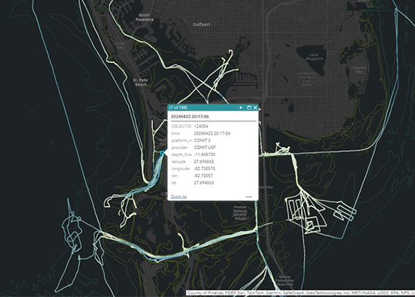
IMAGE ABOVE: A screenshot from COMIT’s web map viewer displaying some of the depth data collected by Eckerd College Search and Rescue (EC-SAR). The points displayed are enlarged to show detail, but already trends in seafloor depth and shape, called bathymetry, are apparent.
For updates about Crowd the Bay, along with COMIT’s other projects, follow them on LinkedIn.
Contact: Center for Ocean Mapping and Innovative Technologies at the USF College of Marine Science, cms-comit@usf.edu.