By: Cassidy Delamarter, University Communications and Marketing
In the days leading up to Hurricanes Helene and Milton, and in their wake, USF researchers have been sharing their expertise around the clock with news outlets across the country. They’ve offered insights on everything from evacuation behavior to the storms’ toll on tourism to new concerns with red tide. USF researchers have conducted nearly 50 interviews with news outlets, including The Washington Post, The New York Times and Associated Press, as well as every local media outlet in the Tampa Bay market. Here are just some of the faculty members who are studying the circumstances surrounding these back-to-back storms.
COASTAL EROSION
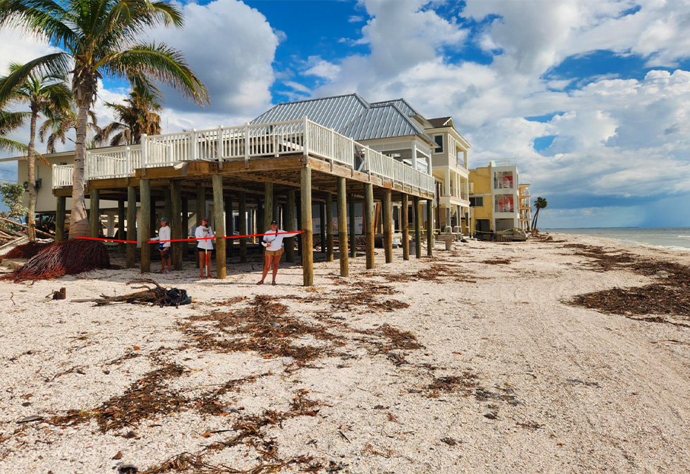
Ping Wang, professor in the School of Geosciences, is assessing the impact of Hurricanes Helene and Milton on coastal dunes and beaches. Through extensive surveys of the Pinellas County coastline before and after each storm, Wang plans to quantify the changes to model future scenarios.
The USF Coastal Research Lab, including graduate students and postdoctoral researchers, observed the aftermath of Helene’s record-breaking storm surge, which caused severe dune erosion, infrastructure damage and widespread sand displacement along the Pinellas County barrier islands. Milton, arriving shortly thereafter, brought negative storm surge, pulling large amounts of sand seaward and hindering natural beach recovery.
“The combined impacts of these two storms practically eliminated the achievements of our shore-protection efforts over the past 40 years,” Wang said. “What is next for beaches along the islands will be a long story with uncertainties.”
Wang plans to use his studies to highlight the importance of large-scale beach nourishments to make the coast more resilient, which requires the constructive involvement of the entire community.
DISASTER PLANNING FOR OLDER ADULTS
Lindsay Peterson, professor in the School of Aging Studies, is developing new proposals to evaluate and improve disaster preparedness policies for nursing homes, assisted living communities and home-based care. Peterson is interviewing care providers, disaster professionals and older adults across Florida to determine if current measures adequately protect this vulnerable population. The goal is to create a new disaster preparedness framework tailored to older adults and caregivers.
Peterson's current project, funded by the Sarasota Community Foundation, involves piloting a disaster preparedness app for caregivers of older adults, which has gained urgency after Hurricane Milton.
“Research and experience have shown us that all disasters are different, and older adults and their caregivers have varying needs depending on where they live, the risks they face, what resources they have, and the level of care they need or need to provide if they are a caregiver,” Peterson said. “The app we are developing will enable older adults and caregivers to develop preparedness plans tailored to their circumstances and needs. The plans could be easily updated as their needs change.”
Testing of the app will begin this year with older adults and caregivers in Sarasota and Charlotte counties. Read more about Peterson’s work here.
SUPPLY CHAIN MANAGEMENT
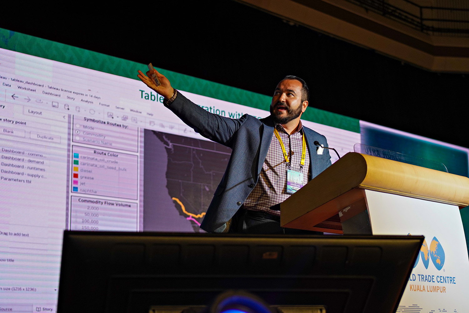
Ozkul presenting USF research on supply chain resiliency at the 4th International Road Federation (IRF) Asia-Pacific Regional Congress & Exhibition in Kuala Lumpur, Malaysia. Ozkul is an IRF Fellow.
Seckin Ozkul, assistant professor in the Muma College of Business, is focused on optimizing supply chain management during hurricanes, particularly for vital items such as fuel and food.
Ozkul is analyzing the impacts of Hurricanes Milton and Helene in USF’s Supply Chain Innovation Lab to create models that reflect the effects of multiple large hurricanes hitting the same region in a short time span.
“The back-to-back impact of Hurricanes Helene and Milton presented new challenges, particularly with fuel shortages, which were exacerbated by the closure of Port Tampa Bay and the increased demand from evacuations,” Ozkul said. “The goal is to support government agencies in making informed decisions to minimize disruptions and optimize evacuation plans during future storms.”
Ozkul’s hope is for the models to be ready ahead of the next hurricane season, so officials can use them to help improve disaster preparedness, particularly for fuel distribution, by rerouting supplies to ensure critical resources are available.
STORM SURGE ASSESSMENTS
Jennifer Collins, professor in the School of Geosciences, is administering surveys in Florida, Georgia and North Carolina to understand how people receive information, how they perceive information and how they act on that information during hurricanes.
“For instance, the Saffir-Simpson Hurricane Wind Scale is the current scale used to communicate the intensity of the hurricane with the public,” Collins said. “Bear in mind though this scale only tells you about the wind threat and, as my research has shown, many people base their evacuation decision on the category of this scale. What if the system was tropical storm strength or a Category 1 and people don’t evacuate, but they get deadly high surge and rainfall totals?”
Collins is collaborating with a team in the Netherlands who proposed a new scale to improve how hurricane risks are communicated beyond just wind speed. The team's research suggests that under this new scale, Hurricane Helene would have been classified on landfall as a Category 5 considering storm surge and wind together and a Category 5 in western North Carolina based on rainfall and inland flooding, while Hurricane Milton would have been a Category 5 based on storm surge forecasts for the Tampa Bay area.
The proposed scale considers multiple hazards and has been better received by focus groups so far. The information gathered in the surveys will be used to further review the new proposed scale and be beneficial for weather enterprises, such as emergency management and the National Hurricane Center, as they consider their communication strategies, tools and even scales.
GULF ALGAL BLOOMS
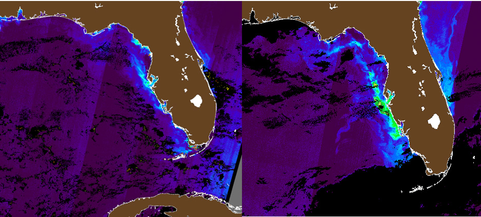
Satellite images captured by Ocean Optics Lab showing a weak algae bloom off Pinellas County prior to Helene (left), and more extensive blooms after Helene and Milton (right). In both images, the light blue-green-yellow indicate high concentrations of algae.
At the USF College of Marine Science, researchers in the Optical Oceanography Lab use satellite observations, numerical models and water samples to study and monitor red tide, or harmful algal blooms, caused by the toxic species Karenia brevis — which occur in the Gulf of Mexico nearly every year.
This season is no exception.
“We have been closely monitoring this red tide, which started before the hurricanes, and we were not surprised by its rapid development afterward,” said Chuanmin Hu, professor of physical oceanography at CMS.
Hurricanes can impact red tide in different ways. For example, they can dissipate them through wave action and wind, or they can worsen them by providing additional “fuel” in the form of excess nutrients from coastal runoff and deep ocean.
In the images, light blue-green-yellow colors indicate high concentrations of algae.
“Before Hurricane Helene, a weak red tide was already present off Pinellas County,” Hu said. “After both Hurricanes Helene and Milton, the algae bloom became more extensive and intense. However, we’ll need to wait for the water samples collected by the Fish and Wildlife Research Institute to confirm whether the bloom is dominated by Karenia brevis or other non-red tide species, such as diatoms.”
WAZE FOR FLOODING
A web-based application that gathers crowdsourced data to identify flooding and inform policy in coastal communities provided scientists with essential data from Hurricanes Helene and Milton. Led by Barnali Dixon, professor in the School of Geosciences, the team, which includes researchers from Georgia Tech University, used the CRIS-HAZARD app to analyze real-time flooding in Pinellas and Hillsborough Counties.
The app combines volunteered geographic information and community crowdsourced data, such as photos and videos, with near real-time information on flooding. Using dynamic modeling and mapping tools, including artificial intelligence, the app can identify and extract estimated water elevation from imagery submitted that will be used to inform emergency managers and policymakers.
Dixon compares it to the real-time traffic app, Waze, where drivers can see traffic back-ups happening along roads and highways.
“People used it to report what was happening in their backyard,” Dixon said. “This information is their lived experience, and we want to take that experience and make data out of it using AI tools that will process images and figure out the depth of the water.”
Read more here.
AN INDISPENSABLE TOOL
As Florida braced for Hurricane Helene, an underwater glider operated by the USF College of Marine Science was in a unique and precarious position — it was the only submersible research vessel in the direct path of the storm.
Deployed by the Ocean Technology Group to monitor red tide, the glider, nicknamed Jai Alai, was carefully stationed at the edge of the West Florida Shelf at a location that ended up being directly in the path of the hurricane.
Gliders are remotely operated submersibles that capture and transmit data from the water column for weeks to months at a time. Data such as temperature and salinity gathered by gliders are fed into oceanographic and weather models, allowing forecasters to better predict the paths and intensities of storms before they make landfall.
“Gliders are not only the most cost-effective technology available to collect ocean condition data for up to four months, but also a safe option for the researchers in our network,” said Jorge Brenner, executive director of the Gulf of Mexico Ocean Observing System. “It would be practically impossible for anyone to collect the complex tridimensional ocean data needed by the National Weather Service across the water column during a storm such as Hurricane Helene. But for Jai Alai, that was possible.”
Learn more about this project here.
Dyllan Furness, Carlyn Scott and Sarah Ward contributed to this article.